
CERPA project aims at improving the exposition evaluation of the population to the atmospherical particles in order to have a better knowledge of their sanitary impact.
It consist in the cartography of the dispersion of the atmospherical pollution by the particles, combining the innovative approachs that are the spatial remote sensing and the digital simulation of dispersion and polluants reactivity.
The CERPA project complete the EXPER/PF project whose salient point was to gather an euro-regional database on particles. This project aims at studying the PM10 spatiotemporal repartition in the Nord/Pas-de-Calais region, using a complementary approach of several technics : AASQA fixed measurement , cartography of PM calculated out of satellite images, and modelling of the PM generation.
The EXPER/PF portal
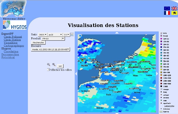
© NASA 2003, processing HYGEOS/ULCO, 2004
Fine particles (PM10) concentration in the atmosphere for a zone centered on the North of France, at the time of an episodic pollution on 13/08/2003, obtained with the american satellite sensor MODIS at 11h20 TU as well as the measurement of the air quality monitoring networks from France, Belgium and England when the satellite was passing (squares). To the right is the common color scale, in mg/m3. Taken from the portal http://experpf.hygeos.com/
Université du Littoral - Côte d'Opale
ADRINORD
PC2A
APPA Nord-Pas-de-Calais